
Volcanoes and Ocean Currents
Introduction
Ocean currents are driven by tides, by wind and by variations in water density caused by variations in salinity and temperature. Their paths are also controlled by the earth’ s rotation in the same way that winds in the atmosphere rotate about low pressure systems. These circular current paths are called gyres.
The Gulf Stream, the Kurashio (Japan) and the Aghulas (South Africa) are well known ocean currents. The flow of ocean currents are measured in Sverdrups, one Sverdrup (Sv) being a million cubic meters of water passing a fixed point in one second. The flow of the Amazon is about 0.5 Sv. The biggest ocean current, the Antarctic Circumpolar Current has a flow of 100 Sv where it runs through Drake Passage between South America and Antarctica. The flow of the ACC is equal to that of two hundred Amazons.
Ocean currents determine local climate. Deserts, such as the Atacama Desert of Peru tend to be flanked by cold currents. Offshore currents flowing towards the equator are generally colder and give rise to less evaporation and less precipitation, whereas warm, pole-ward currents lead to enhanced evaporation and higher rainfall. On the other hand pole-ward currents are generally poor in life-supporting nutrients compared with equator-ward currents. The Labrador current flows between Greenland and Canada and carries nutrient southward to nourish the cod fishery of the Grand Banks of the North Western Atlantic.
It is commonly assumed by oceanographers that world ocean currents have remained fundamentally unchanged since the last ice-age termination 11,000 years ago. Historical and archaeological evidence indicates that this was not the case.
The Greenland Vikings
The Vikings, more correctly the Norse, were a sea-faring people who raided, traded and often farmed European coasts and river systems from Greenland to the Black Sea. We know from their middens that they ate fish. We know that for them fish was a low status food; meat was high status food.
The Norse settlements in South Western Greenland (980 AD to 1435 AD) were an exception. The middens of these settlements contain the bones of aquatic mammals but no fish bones. Since these people were culturally identical to Norse in other parts of Europe it seems likely that, unlike today, there were no fish available to them. This suggests in turn, that ocean circulation was different at that time.
Easter Island
A similar puzzle concerns the consumption of porpoise by the inhabitants of Easter Island. According to Jared Diamond in his book Collapse:
Comparison of early garbage deposits with late prehistoric ones or conditions on modern Easter Island reveals big changes in … initially bountiful food sources. Porpoises and deep ocean fish like tuna,virtually disappeared from the islander’s diet.
According to J. Loret in Easter Island. Scientific exploration into the world’s environmental problems in microcosm:
Throughout Polynesia archaeologists have found that 90 percent of middens consist of fish or shellfish. On Easter Island however, from the period of 900 – 1300 A.D. one third of the bones were of porpoises. Yet nowhere in Polynesia do the bones of porpoises account for more than one percent. These marine mammals had to be hunted far offshore indicating that their craft had to be sufficiently seaworthy and constructed from large trees.
Both authors are reaffirming the accepted narrative that Easter Islanders destroyed their own livelihood by cutting down all the big trees from which they constructed their canoes.
Maps of the present day distribution of the four major species of porpoise indicate that there are no porpoise within thousands of kilometres of Easter Island. It seems unlikely that early Easter Islanders could have travelled so far to hunt these animals; there must have been porpoise closer to the island. Today the ocean around Easter Island is very poor in nutrients. There is no marine ecosystem sufficiently large to support a top predator such as porpoise; there is insufficient nutrient available to generate such an ecosystem.
Once again this implies that ocean circulation between 900 and 1300 AD differed from that of the present day. These events both occurred at a time of warm weather in Europe known as the Mediaeval Warm Period and suggest that changes in ocean circulation accompanied and perhaps even caused the MWP.
Finally, consider the Maya, a civilisation which flourished on the Yucatan peninsula of present day Mexico from about 400 to 900 AD. Oxygen isotope ratios and sulphur abundances in lake sediments from Yucatan suggest that the cause of the Mayan Collapse was sustained drought.
The Mayan drought immediately preceded the Mediaeval Warm Period.
Subaqueous Volcanism
But what caused these changes? A promising candidate is subaqueous volcanism.
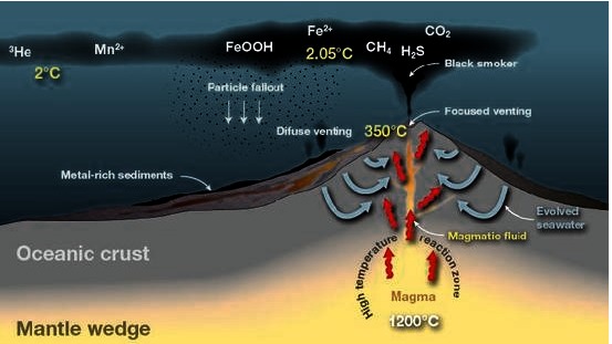
Subaqueous volcanism refers to volcanic activity beneath the surface of the ocean as distinct from subaerial volcanism which refers to volcanic activity on land. It is believed that subaqueous volcanism accounts for eighty-five percent of all volcanic activity, subaerial five percent so that volcanic activity is more than five times more common under the sea than on land. The rapid formation of steam when water flash boils on contact with hot magma is the reason for the explosive power of subaerial volcanoes. The large pressure at the bottom of the ocean prevents water from boiling and forming steam. As a consequence ocean floor volcanoes are much less likely to be explosive than are those on land: five percent compared with eighty percent.
Instead subaqueous volcanism takes the form of hydrothermal vents (HTVs). These were first discovered in 1977. They are also known as “black smokers” and lie on mid-ocean ridges and above volcanic hotspots at depths of two to three kilometres. They are formed when seawater penetrates the ocean floor and comes into contact with hot magma. The heated water then exits through vents as black plumes which rise 100m or so above the ocean floor. The vents are often surrounded by strange life forms; life forms which utilise the free energy of the chemicals in the plume and are not dependent on sunlight and photosynthesis.
Instead of boiling, the circulating seawater becomes “supercritical” when it is heated above 374°C at high pressure. Supercritical water is neither a true liquid nor a true gas and contains nascent oxygen and hydrogen ions. It is a hot oxidising acid and highly corrosive. It is so corrosive that it tears rocks apart chemically. As a result HTV plumes contains heavy metals and hydrogen sulphide which combine as the plume cools and precipitate onto the ocean floor as metal sulphides. These precipitated metal sulphides make very rich ores. The Mount Isa ore body is comprised of sea floor sulphides created in this way. Some mining companies such as Nautilus Minerals intend mining HTV sulphides directly from the ocean floor.
Known HTVs release 17 terawatts of power into the ocean as heat, about the same as global human usage of energy. Each year they pump into the ocean 500 tonnes of Arsenic, 1500 tonnes of Lead, 50,000 tonnes of Copper and 140,000 tonnes of Zinc and many other metals. They have been doing this for a billion years. These metals are rapidly precipitated as sulphides which explains why their concentrations have not built up in sea water. In fact HTVs may have the net effect of actually cleansing sea water of dissolved metals by this sulphide precipitation reaction.
Megaplumes
Volcanism on land is intermittent, random and explosive. Although subaqueous volcanism is less likely to be explosive there is no reason to assume that it is not similarly intermittent and random. Major subaerial volcanic events of the magnitude of Krakatoa occur once per century. It is likely then that subaqueous events of the similar energy to Krakatoa occur four or five times per century.
Detailed examination of HTVs is expensive. It requires the deployment of remotely operated vehicles from specially equipped research vessels. Only a small fraction of the 50,000 km of mid-ocean ridges has been explored and even then sites of interest are only visited occasionally. The long term variability of HTV fields remains almost a closed book. In the absence of observations the best we can do is to assume that subaqueous volcanism varies over time in a similar way to subaerial volcanism. We can expect that, from time to time, subaqueous volcanic events will occur which gives rise to plumes much larger than those routinely observed. In fact remnants of such plumes, called “megaplumes”, have been observed as anomalous chemical signatures high in the water column. Small patches of high sea surface temperature indicative of megaplumes have been recorded by satellites.
There is an aspect of megaplume formation which has hitherto been ignored. HTV plumes which typically have an exit temperature of 360°C are rapidly cooled by the entrainment of surrounding sea water until they lose buoyancy and spread horizontally much like chimney smoke on a frosty night. However plume dynamics indicates that for a large plume the temperature of the plume interior could remain sufficiently elevated for the water to boil as the hydrostatic pressure decreases with decreasing depth. Indeed one HTV field, the Lucky Strike field near the Azores, is sufficiently shallow at 1700m depth for effluent to be close to boiling point as it exits the vents.
Once boiling commences, plume dynamics alters radically. The formation of steam bubbles greatly increases the buoyancy of the plume causing vertical acceleration of the effluent stream leading to increased further boiling and so on. In effect, the plume becomes a geyser.
Using buoyancy calculations alone and neglecting heat losses, one litre of vent effluent at 360°C, when it boils in a megaplume, will create sufficient buoyancy to lift 30 tonnes of cold sea water to the surface. A sufficiently powerful HTV field can conceivably generate enough buoyancy to turn an entire ocean basin upside down.
The most powerful HTV field so far discovered is the TAG field on the Mid-Atlantic Ridge. The power output of the TAG field is around 6 GW. It lies at 26°N, the same latitude as the Yucatan Peninsula, one-time home of the Mayan Civilisation. We can speculate that the TAG Field is the remnant of a major subaqueous event with a megaplume which transported large volumes of cool deep ocean water into the tropical mixed layer so cooling the sea surface. This led to decreased ocean evaporation and drought in Yucatan.
Upwelling
In addition to changing the surface temperature, a megaplume changes the surface composition of the ocean. Most of the ocean surface, the mixed layer, contains very little nutrient, particularly the deep ocean well away from land. Most of the nutrient and hence most of the plankton and other living organisms are found on continental shelves where nutrient is continually replenished by river run-off from the land. In many parts of the deep ocean, nutrients such as nitrate, phosphorus and silicate are in plentiful supply at depths of 1000m or so but support no life there because essential sunlight cannot penetrate to this depth. This is true of the South Atlantic and North Pacific for example. In some places deep ocean water is forced to the to the surface. When this deep water contains sufficient nutrient, plankton blooms and a marine ecosystems form. Fifty percent of the world’s commercial fish come from such nutrient-rich “upwellings”.
Ocean upwellings are caused by the deflection of ocean currents by ridges, seamounts and coastlines. However a megaplume from an HTV field can have a similar effect. Easter Island lies close to the southern edge of the North Pacific nutrient mass and also on the North Pacific Rise, the world’s fastest spreading mid-ocean ridge and one of the most active. It is likely that a megaplume from an HTV field on the East Pacific Rise supported a mid-ocean marine ecosystem during the period in which Easter Islanders dined on porpoise.
Carbon Dioxide Flux
In The Voyage of the Beagle Darwin opens his chapter of on the Galapagos Islands with the following remark:
Considering that these islands are placed directly under the equator, the climate is far from being excessively hot … this seems chiefly caused by the singularly low temperature of the surrounding water, brought here by the great southern Polar current.
In fact three ocean currents converge near the Galapagos, the current to which Darwin referred, now known as the Humboldt Current, its Northern Hemisphere mirror image, the California Current and the Cromwell Current also known as the Equatorial Counter Current. The first two currents cause deep, nutrient-rich, cold water to come to the surface with the result that the waters around the Galapagos are relatively cool and well-endowed with marine life. The presence of iron in the upwelled water suggests that HTVs above the Galapagos’ volcanic hot-spot contribute to this upwelling.
The last-named current, the Cromwell Current, contributes very little because it is shallow (from 40m to 200m in depth) and poor in nutrients such as Nitrate and Phosphate. In fact the Cromwell Current has the effect of diluting the nutrient upwelling brought about by the other two currents and the HTV field.
Although poor in nutrients, the Cromwell Current is rich in dissolved inorganic carbon with the result that, when this current comes to the surface near the Galapagos, excess carbon is released into the atmosphere as carbon dioxide. A simple calculation shows that three gigatonnes of carbon dioxide are outgassed per year, i.e. equal to about half the calculated human contribution per annum.
The outgassing of CO2 by ocean currents and upwellings depends on the available nutrient and the final temperature achieved by the initially cold, upwelled water. Like most gases CO2 is much more soluble in cold water than in warm water. This is something we experience when we fail to return an open bottle of soft drink to the refrigerator on a hot day. In contrast in temperate and polar regions the upwelling of nutrients generally leads to the net absorption of CO2 from the atmosphere due to photosynthesis by phytoplankton. The atmospheric carbon taken up by the biomass is ultimately returned to the deep ocean in the form of faecal and skeletal material.
Conclusions
The total power expended in volcanic heating of the ocean is well in excess of the power dissipated by wind stress and tidal friction. There is growing evidence for the existence of volcanically generated megaplumes both from satellite imagery and from direct observation. Although the physical detail remains to be explored there is growing evidence that megaplumes are, at times, responsible for variations in climate, ocean productivity and ocean export of CO2.
There is a vast amount of CO2 stored in the ocean: 38,000 Gigatonnes compared with 380 Gigatonnes generated by human activity since the beginning of the industrial revolution. It is doubtful whether mankind’s modest one percent contribution has made very much difference.
Nevertheless oceanographers seem quite reluctant to acknowledge the role of subaqueous volcanism in influencing ocean circulation, ocean ecology, climate variation and CO2 flux. Why should this be so?
One possible explanation is that oceanography and climate science have come to be heavily dependent on numerical fluid dynamic modelling. “Ocean-atmosphere general circulation models” or OAGCMs have become the preferred means of investigating ocean circulation. The ocean-atmosphere model is tuned to settle down, after “spin-up”, to a steady state where it remains until deliberately perturbed by some external factor such as changing the atmospheric concentration of carbon dioxide. According to these models the ocean in its natural state is a sort of machine, a conveyor belt steadily carrying heat, salt and dissolved gases around the planet’s oceans in the same unvarying manner until it is disturbed by humankind.
Volcanic activity does not fit this neat picture. Volcanic behaviour is random, i.e. it is “stochastic” meaning “governed by the laws of probability”. For fluid dynamic modellers stochastic behaviour is the spectre at the feast. They do not want to deal with it because their models cannot handle it. We cannot predict the future behaviour of subaqueous volcanoes so we cannot predict future behaviour of the ocean-atmosphere system when this extra random forcing is included.
To some extent, chaos theory is called in as a substitute, but modellers are very reticent about describing and locating (in phase space) the strange attractors of chaos theory which supposedly give their models a stochastic character. They prefer to avoid stochastic descriptions of the real world in favour of the more precise but unrealistic determinism of the Navier-Stokes equations of fluid dynamics.
This explains the reluctance of oceanographers to acknowledge subaqueous volcanism as a forcing of ocean circulation. Unlike tidal forcing, wind stress and thermohaline forcing, volcanism constitutes a major, external, random forcing which cannot be generated from within the model. It has therefore been ignored.
Acknowledgements
This article was published as “Ocean Vents and Faulty Climate Models” in Quadrant Online on 3 May 2014. See:
http://quadrant.org.au/opinion/doomed-planet/2014/05/ocean-vents-faulty-models/
A pdf file including references can be found here
I would like to thank Wayne Hooper for helpful advice and comment.
Comments from Climate Etc post
scotts4fs
Temperature at great depth in the ocean is 0-2 *C. Large heat capacity but rapidly equalizes any volcanic or sea floor spreading heat input to remain largely stable at near 0*C. If one can’t measure the tempeature difference with current technology, which is as your comments before at some open forum indicated, we can’t know what the “greater impact or previously thought” impacts are. Could be a lot or might be trivial. All so uncertain.
Scott
John Reid
It is a question of plume dynamics. As hot water rises it is cooled by entrainment of surrounding cold water but at the same time the pressure is falling with decreasing depth. If the plume is sufficiently large it is conceivable that boiling may occur in the interior of the plume. Should this happen the buoyancy of the steam will radically alter plume dynamics leading to faster rise times, more boiling and so on, as in a geyser. Such a boiling event could entrain a much larger amount of cold water and carry it much higher in the water column. A Krakatoa-size eruption in the right place could initiate basin overturning. It is about time someone modelled this.
Thanks John,
From the outset, when I was first confronted with catastrophic climate speculation, my intuitive formulation of the actors on climate was that the biosphere is the interface of two primary energy inputs;the sun and the earths core. To model the climate you first need to be able to model those systems and work inwards from there. Presently, it seems the models start by taking the rather random temperature at arbitrary places an try to project outwards, concentrating on the radiative gases for (perhaps)largely political reasons. The system is so large and as yet not fully understood that projections based on current knowledge are of little use except for daily weather forecast. Thanks for a very interesting read.
John said: ” Such a boiling event could entrain a much larger amount of cold water and carry it much higher in the water column.”
Now you’ve planted a mind worm. Early in my working life I did engineering calculations on air lift in drilling and mining aplications, it’s a long time ago but I see I’ll have to revisit that along with some steam tables…..now just to find the time.
John,
The other variable effect from within the earth that I expect may have an effect on climate, one which I’ve found little info on, is what I think of as the relative roughness (or smoothness) of the earth’s surface. By that I mean, ignoring for a moment celestial and centrifugal tides, if the earth was an entirely smooth sphere it would be entirely covered in (shallow) water. Relatively small perturbations of the crust could conceivably displace large volumes of water over a period of years. This of course is different to the accumulated plume instability you suggest or tectonic plate movement. I expect they are related. My mathematical prowess gets bogged at tackling a basic model but my intuition suggests it’s another variable left out of the modelling.
It’s a very complex problem. A former colleague, Trevor McDougall, was an expert on plumes and gave me some good advice early on. See
http://www.ecofluidics.com/UGEMO/UGEMO.pdf
I did have a paper published,
Reid, J. (2010) Modeling a Two Phase Fluid in a Riser. J. Ocean Technology, vol 5 82-96
but that was with the plume contained by a pipe.
As a non-scientist, I found this a luminous piece of writing. It manages to explain complex processes in a way that is lucid, allowing for their interactions, and for those areas where observation is still scant and knowledge uncertain. Its effect is to disarm the spook-mongering, to place Earth’s processes and human contributions to them, in their credible scale to each other. As a descendant of those Westward migrating Norse, I am particularly interested in the way current activity might be read into the record of their (and Mayan, Easter Islander) middens.
Viva such explanatory science!